Traffic Speed Surface Condition Surveys
See defects for yourself
Zetica can provide surface condition data derived from laser-based measurement devices as well as images of the pavement surface and surrounding carriageway corridor using a wide variety of camera options and deliver it to you in simple to use but powerful desktop viewing software.
Pavement surface VCS (visual condition survey) is a mainstay operation in UK pavement assessment policy. However, here at Zetica we believe that visual condition surveys should not mean walking the carriageway. Our tiered solution is carried out within live traffic at the prevailing speed from our specialist vehicle. Starting from a basic visual image survey where you can select from a range of camera options and configurations right up to a fully realized, comprehensive survey utilising the latest laser based automated defect mapping system (LCMS-2).
We can provide a viewing platform whereby you can interrogate the data yourself for defects or alternatively our trained and experienced data analysts can do this for you and present the defects they find in our RASC viewer platform as well as in other formats such as schematic plans of the site (commonly referred to defect strip maps in CS 229) and geospatial data layers compatible with industry standard software packages.
Carrying out VCS surveys from imagery and remotely sensed laser data provides obvious benefits in safety as it reduces the need for inspectors to visit the carriageway as well as providing the opportunity for quality assurance and auditing of the delivered data.
LCMS-2 data analysis
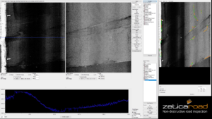
The Laser Crack Measurement System (LCMS-2)
The LCMS-2 is the latest automated pavement surface deterioration mapping sensor which delivers full lane width 1mm resolution imagery and height data. The algorithms built into the software can deliver industry standard and specialist parameters such as cracking, rutting, texture, potholes, fatting, shoving, aggregate loss and roughness.
Zetica can provide LCMS-2 parameters within the RASC viewer alongside other data such as imagery and GPR. We can also provide data compatible with industry standard GIS and CAD platforms or work with you to develop a custom format for you to use in existing software e.g. a pavement asset management system.
Case Study
Coming soon…
Keen to find out more?
To discuss road surveys with one of our experts or to get an estimate for our services, please call (0)1993 886 682, email roads@zetica.com or contact us online.